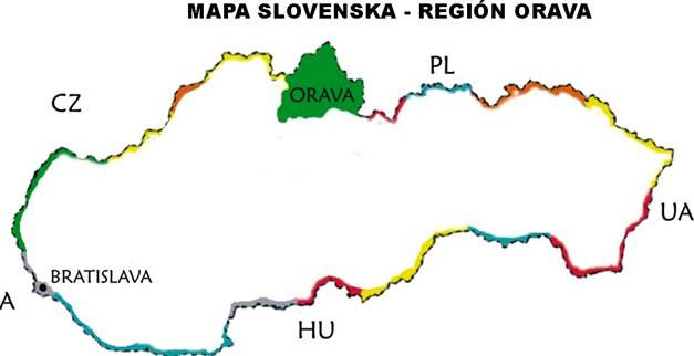
Orava is the northernmost and coldest region of Slovakia with picturesque nature and fresh air. It is situated in the north-western part of Slovakia, at the Polish border. It covers over 1660 km2. The border point in the cadastral territory of the village Oravská Polhora is the northernmost place of Slovakia.
The axis of the region was formed by the Orava, a river almost 112 km long and one of the river-basins of the Black Sea.
Orava is inhabited by around 135,000 residents with a population density of 75.6 residents/km2. Almost 35% of the residents live in 4 cities: Dolný Kubín (approx. 20 000), Tvrdošín (8 000), Námestovo (8 000) and Trstená (8 000).
From an administrative point of view, it is divided into 3 districts, namely Dolný Kubín, Tvrdošín and Námestovo. The region is one of the most attractive Slovak tourist regions.
The district town Dolný Kubín, which is at the centre of Dolná Orava, is known for its rich history, numerous sites and water park. An important and dominant feature of Dolná Orava is Orava Castle, which is located on the top of a 112-metre-tall rock over the Orava River in Oravský Podzámok.
Námestovo is a well-known tourist centre, seat of the district and thus also of Biela Orava. Its location on the north-western side of the Orava Reservoir is ideal for recreational activities. Námestovo district is important for Oravská Polhora, the northernmost point of Slovakia.
Tvrdošín is the picturesque administrative centre of Horná Orava. It lies on a very important arterial road to Poland. Horná Orava is famous for its thermal streams and pools in Oravice. Tvrdošín district is known for one of the most beautiful parts of Orava – Western Tatras and Roháče. Roháče valley is bordered by beautiful summits under the reign of the exposed Banikov, Ostry Rohač and Plačlivo.
Roháče is part of the protected Tatra National Park. The district town of Horná Orava, Tvrdošín, was awarded a prize by Europe Nostra in 1993 for preserving a wooden church from the second half of the 15th century. The church is now on the UNESCO World Heritage List.
Thanks to its varied terrain configuration in north-western Slovakia, Orava has a very interesting border. In the past, the geographical conditions led to Orava’s designation as an individually closed administrative unit.
From the north, it is sealed by the Slovak-Polish border mountain Orava Beskids, which are part of the Carpathian arch. Important hills in the area are Pilsko and Babia hill. Another boundary is formed by a spur of the Orava Beskids, streams bordering Kriváň, Chyžník, Jelešna, and the peatlands near Suchá hora.
From Suchá hora, the border runs along important terrain objects – the northern spurs of Magura behind Poľana Molkava, through a quiet valley over the Furkasky ridge, and along the Bobrovec ridges. The southern border consists of the Western Tatras ridges. The border then crosses the Choč mountains and Little Fatra ridges. The border between Kysuce and Orava consist of the eastern spurs of the Kysuce mountains, the saddle over Oravská Lesná and the foothills of Orava Beskids.

CONTACTS
Klaster ORAVA, o.o.c.r.
Hviezdoslavovo námestie 1651/2
026 01 Dolný Kubín
ID number: 42219701
VAT: 2023413898
ID VAT: SK2023413898
E-mail: marketing@orava.sk
Telephone: +421 911 747 339


